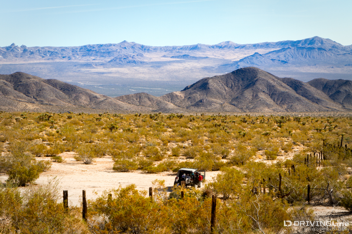
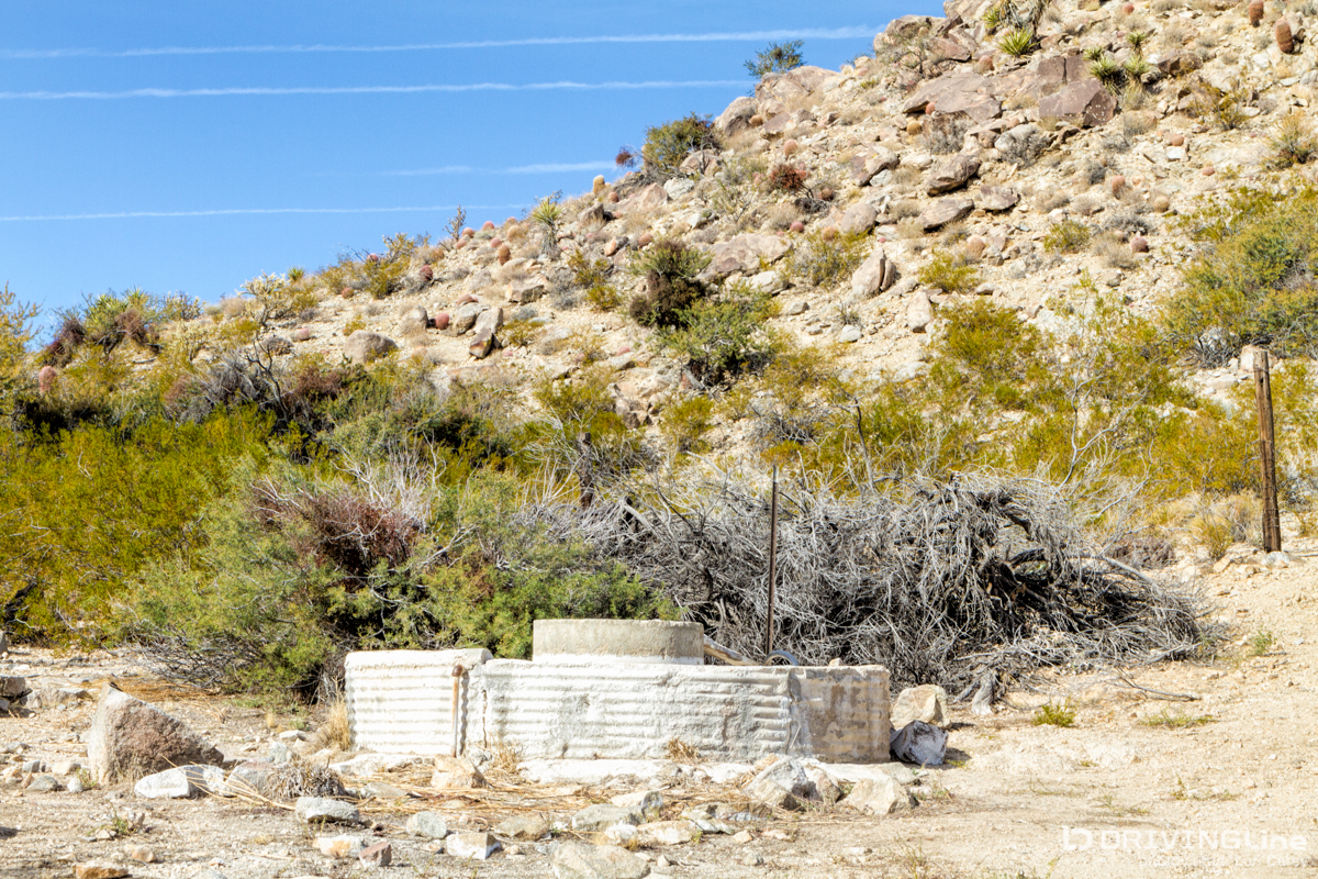
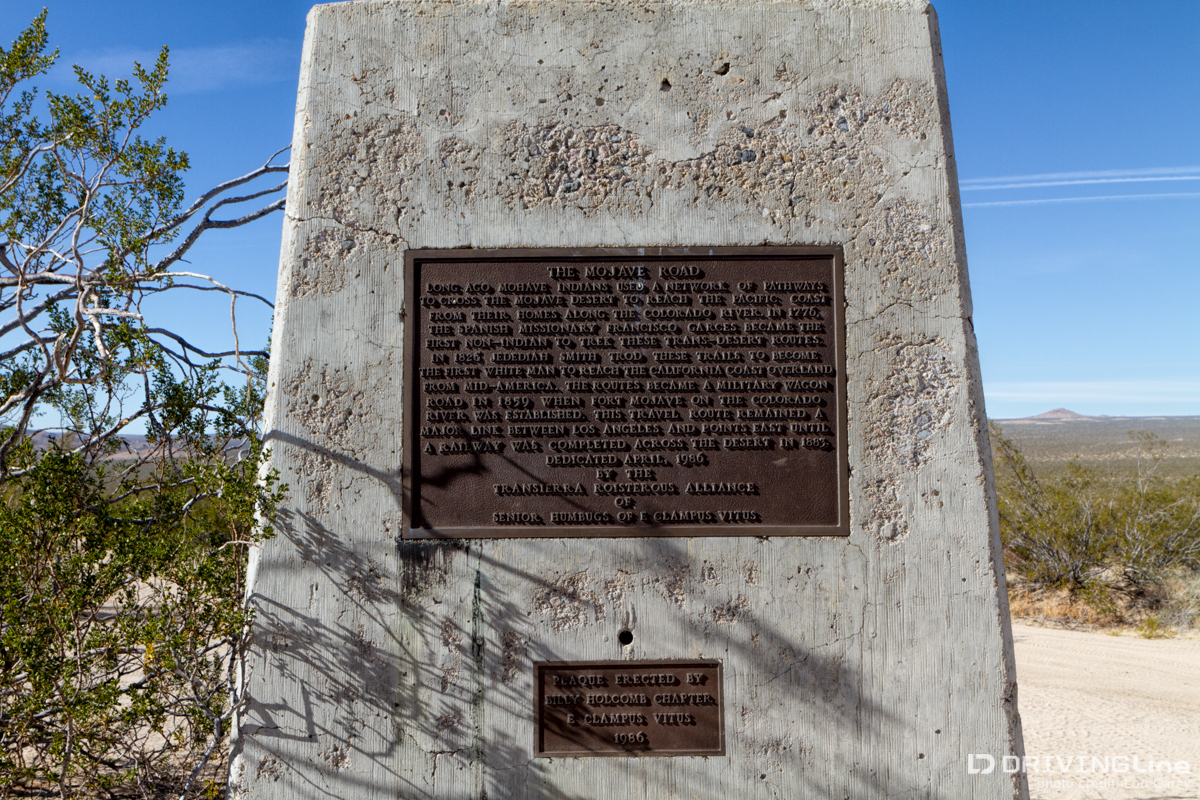
My three-day trek on the historic Mojave Road Trail was a terrific way to adventure, off-road, and see a seldom-traveled slice of Southern California. If you missed the first two parts of my journey, where we covered Needles to Marl Springs via Soda Lake, make sure to check out Part I and Part II of this Mojave Road trail review. We stopped at Marl Springs to do some exploring and eat lunch. Marl Springs is the most important water source along the route because it is more than 30 miles to the next reliable water source at the west at the edge of Soda Lake. There was a small army outpost here briefly in 1867-68, the only outpost along the trail that ever came under attack by Indians. Later, during the wagon road period it was a place where travelers could purchase supplies. To this day it is an important location for the cattle industry and there is a corral and watering facilities on site. The dugouts here were used by the Army as living quarters, imagine that! Marl Springs has also been used by prospectors and miners over the years and you can find the remains of an arrastre, which was built to grind gold-bearing quartz. There used to be a brass plaque here which read: "Pozos de San Juan de Dios"On March 8, 1776, Fr. Francis Garces, O.P.M., on his most famous journey of over 2,000 miles from Mission San Xavier del Bac, Tucson, Arizona, to Mission San Gabriel, rested here and named these waterholes "St. John of God Springs," (Marl Springs), and on the return journey passed through here, May 22, same year."Erected by the Hospitaller Brothers of St. John of God, Saint Mary Desert Valley Hospital, Apple Valley, California, 1972, in cooperation with the San Bernardino County Museum." Controversy ensued over the probability that Garces actually visited Marl Springs, based upon the information in his log book. The plaque is now gone, whether stolen by someone who wanted the brass or removed because the historical information could not be definitively confirmed. The spring was a lush oasis when we visited, the mud surrounding the water was filled with animal tracks and it sounded as if there were hundreds of birds singing. It was quite a change from the rest of the trail and a beautiful spot to stop for lunch, but we had to keep pushing on. The trail joins the maintained Cedar Canyon Road for a bit. We decided not to stop at Camp Rock Springs, the location of another Army outpost, or Government Holes where the well is still used to this day by the cattle industry, so we could spend more time exploring other areas. It was too early in the day to set up camp in Caruthers Canyon, another favorite location in a pinyon forest above the trail, so we kept moving. When we reached the intersection at Kelso-Cima Road, where you can find the only plaque marking the trail, we decided it was time to head out for gas. The blow sand had been so deep through most of the trail that in 24 hours and just over 70 miles of trail, we already used our jerry can of gas and had only a quarter tank of gas left. From this point it is just about 25 miles to the nearest gas station, so it’s a 50 mile detour off the trail. One of the most important things to know before doing the Mojave Road is the location of the nearest gas stations so you can plan accordingly, and pay close attention to your gas gauge. Back on the trail we continued east toward Lanfair Valley. A section of the trail here is part of the local drainage system and it becomes a ditch, like a deep narrow canal. Any vehicle with a wheelbase wider than a Jeep would need to straddle the notch with its tires on the side walls. It was so narrow that I couldn’t even open a door. We decided to do some exploring in Lanfair Valley and found a side trail that headed toward the Hackberry Mountains. There’s a lot to see in this area including petroglyphs at Indian Well and the ghost town remains of Lanfair, but we got sidetracked with a hike to check out an old water drilling rig in the middle of the valley, a reminder of the days when people optimistically farmed this area. The sun was getting low in the sky and the wind had started to blow hard, so we headed toward the base of the mountains in search of a sheltered campsite. Finding nothing suitable near the base, we entered one of the canyons and worked our way deep into the mountains. The trail was steep and rocky and it was almost dark - we were about to give up hope and spend the night in the Jeep when we finally found a suitable spot with an existing fire ring, sheltered on three sides by looming peaks, and set up a cozy camp before darkness set in. Again, reinforcing the need to really be prepared before venturing out here (especially if you go alone), the display on my brand new gps unit, loaded with trails, waypoints and breadcrumbs, went dark while we were working our way up the mountain. The unit was working but the display was blank, so I couldn’t see where we were or how to find a trail leading out. I had only a general idea of our location. I got a little concerned, not because I didn’t think I couldn’t eventually find my way out, but because it now looked like the weather might take a turn for the worse. Fortunately, I had a handheld gps unit in my backpack and I breathed a sigh of relief as I confirmed our location and that there was a shorter way out of the mountains than how we came in. We woke the next morning at daybreak to find heavy storm clouds rolling in. We knew that the steep trail out was not a good place to be during rain, so we immediately packed up camp without even taking time for breakfast. It wasn’t long before we reached the maintained Lanfair Road and took that out to I40 in Goffs. The rest of the Mojave Road would have to wait for another day! We made it to pavement before the rain started for the fun drive home. If you’re interested in traveling the Mojave Road I strongly recommend obtaining a copy of The Mojave Road Guide by Dennis Casebier. Casebier is the man responsible for the preservation of this historic trail and his guide book contains a wealth of information about the history and sights along the trail, as well as a highly detailed mile-by-mile trail guide. Make sure you are well prepared for desert travel and things that can go wrong, and know where the towns with gas stations are located. Unless you are very experienced and willing to take the risk, this long remote trail should always be done with at least two vehicles.
What are your favorite off-road trails? What trail review do you want to see us feature next on DrivingLine?