Mangled Metal and Windy Memories on the Grass Valley Trail

Join us as we battle high winds and try to find shelter along the 50-mile Grass Valley Trail in the Mojave Desert.
Starting a 50-mile trail late in the day when we had no idea if there would be a suitable place to camp may not have been the smartest decision, but the alternative was to drive 20 miles north to Ridgecrest and hunker down in a hotel for the night. The Mojave winds were raging and our intended campsite at Trona Pinnacles wasn’t realistic. High winds are always a possibility in the Mojave Desert, but springtime brings the worst of it. It’s not unusual to have steady 30 mph winds with gusts exceeding 70 mph during the spring, and this was one of those days. We could see dust devils twirling all around us, we had been getting battered all day while out shooting, and we needed shelter for the night.

The Grass Valley Trail is an easy 50-mile trail through several scenic Wilderness Areas, but it’s very remote and you need to be well prepared. On holiday weekends you may see occasional ATV traffic, but at other times I’ve never seen another person except during the spring wildflower season. The trailhead begins on Red Mountain-Trona Road north of Johannesburg on RM1444 (Steam Well Road).

The wide and sandy trail enters the Golden Valley Wilderness and heads east as it winds its way around the north side of Red Mountain. RM1444 is the only designated motor vehicle travel route through this wilderness area. At Mile 4, you’ll reach the Steam Wells petroglyph site, marked with a sign and a small parking area. It’s a one mile uphill hike to reach the petroglyphs. There is a campsite about a mile past the petroglyph site, but we decided to push our luck and see if we could find a more sheltered location.

Golden Valley lies between the Almond and the Lava mountain ranges. It is a great area for wildlife viewing and we were happy to spot an endangered Mojave ground squirrel. We were disappointed to see new fencing along the wilderness boundary to the north, but it’s understandable when you see the evidence of illegal off-trail travel.

After 15.5 miles, when the trail passes Almond Mountain, it turns south at the Black Hills and enters the Grass Valley Wilderness. The historic Blackwater Well, a 19th century US Army water stop along the trail to Death Valley, is located near the turn. The well is also along the route used by the Twenty Mule Teams when hauling borax from Death Valley.

The sun was sinking low and we thought that the color of the grass this time of day might be why this area is named Golden Valley.

The wind was still howling and there was no shelter in sight. We love traveling through these valleys when we can take our time and enjoy the scenery, but we were cursing it this trip. There was nothing on the horizon, the wind was blowing from all directions, and the sun was about to sink behind the mountains. The only thing in our favor was that the first half of this trail is easy sand and we were able to make decent time.

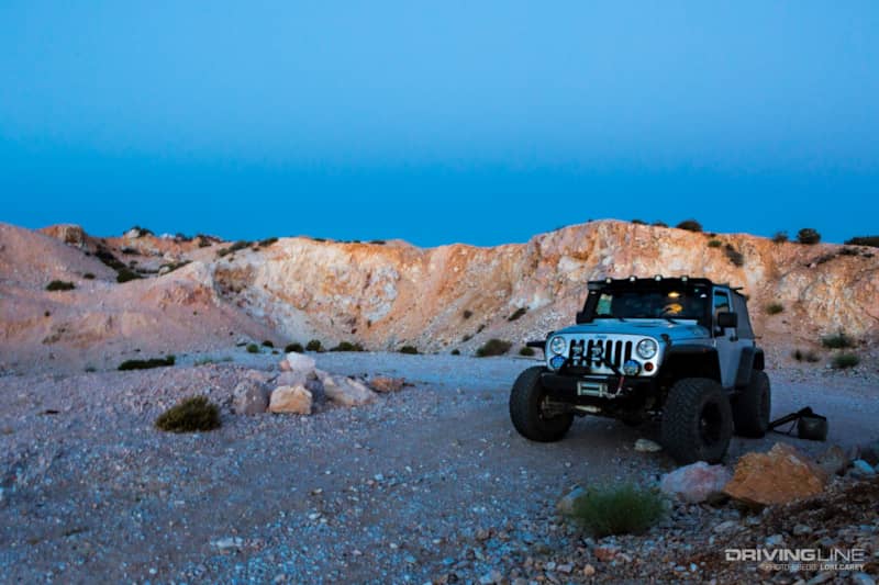
By 8pm, the sun had set and a beautiful full moon was rising. Unfortunately, the winds were still raging. We had been on the trail for more than 20 miles and were still in the wide-open valley without a sheltered location for the night. Since we were on a designated travel route through a Wilderness area, heading off trail toward the mountains wasn’t a possibility. There wasn’t even a place to pull off the trail. We were beginning to concede that we would be spending the night in the Jeep right on the trail in the valley. Anyone who has spent time in the desert knows that the wind usually gets even stronger at night.
We had been on the trail for 25 miles when we exited the Grass Valley Wilderness. We remembered that there was a mine nearby and decided to stop for the night no matter what we found. We got lucky because there was a large area dug into a hillside that was semi-sheltered on three sides. It even had a fire ring, although there would be no fire tonight. The wind was still too strong to set up a tent, but at least we could finally stand upright. We used the Jeep as a windblock for the camp stove. We cooked up some steak fajitas, and settled in to watch a movie in the Jeep while the wind raged outside. The front seat of a Jeep is not the most comfortable place to sleep, but we must have been exhausted from fighting the wind all day because we both fell asleep immediately.

When we woke the next morning, the wind had finally died down. It was a beautiful sunny day with mild temperatures in the 70s, much cooler than it usually is in the desert this time of year. After a breakfast of omelets and plenty of coffee, we were back on the trail in no time at all. Packing up was easy since we had slept in the Jeep.

Our trail book said to make a left onto an unmarked trail at the large Joshua tree. This is the large Joshua tree you are looking for. It’s been dead for years, and most likely left in place as a landmark.

Two miles from camp we stopped at the Husky Monument to pay our respects. The monument began as a single Husqvarna 390 motorcycle buried in the middle of nowhere to memorialize Jim Erickson. Erickson loved riding in this area, and after his death in 1987 his family scattered his ashes and buried his bike here with a small plaque. A few years later, someone got the idea to memorialize other riders, and the site has grown every year. Each memorial is handcrafted with care and tells something about the rider. The last time we were here was a Thanksgiving weekend and more than a hundred people had traveled out to visit the memorial. This time we had it to ourselves, and we spent an hour reading each of the memorials and photographing them. This is hallowed ground for desert riders.

After visiting the memorial, we turned left and entered the Gravel Hills. You need a high-clearance vehicle through this section because there are a few miles of deep whoops and we couldn’t help but laugh when we noticed that the last person to travel this section had dragged their axle’s differential housing along the top of every ridge, leaving a definite mark for miles.

There are some rocky sections when the trail enters a canyon, but it’s not terribly rough. The scenery back here is gorgeous.

The rocky desert terrain can be hard on your vehicle, especially your tires. This isn’t a place you’d want a flat tire. While we run a fullsize spare, our trip was flat-free thanks in part to our Nitto Trail Grapplers.

Seven miles from the Husky Monument, we crossed over the graded Lockhart Road and then turned north onto RM3655/Lockhart. In one mile, we found the F-22 Crash Site. The military often tests planes in the Mojave Desert, and there are enough crash sites throughout the desert that hunting them is a big hobby for some people. This plane was out of nearby Edwards Air Force base. Pilot Dave “Cools” Cooley lost his life when his F-22 Raptor crashed here on March 25, 2009. It’s said that the debris field from the crash spanned many miles. The area was sanitized by the military, but the desert is still giving up pieces of the wreckage. There is a small pile of parts placed near the plaque.

You can turn left onto Fremont Road (formerly EF411) and visit the Monarch-Rand mine, also known as the Fremont Peak Gold Mine. If you haven’t been, we highly recommend a visit. It is the creepiest mine we have ever visited, and not just because we were there at night. Bring a flashlight and be careful because the vertical shaft is very deep. Fremont Road will take you back out to U.S. 395. Since we had visited the mine before, we decided to continue straight and go play on the dry lake beds. The trail passes through two small dry lakebeds before reaching the 6.5 mile long Cuddeback Dry Lake. The lakebeds are a favorite for some high-speed off road action, so keep your eyes open for other enthusiasts.

Along the way we spotted some great campsites with a scenic view of Cuddeback Dry Lake. If you are the adventurous type, there is plenty more to explore in the area around Cuddeback Lake. At one time there was an Air Force Air to Ground Gunnery Range out here. The abandoned base is fenced off, but you can still find artifacts in the surrounding area. We’ve also found other mines and a very old cemetery tucked into the hills that I’ve never been able to find information about and doubt I could ever find again.

After 50 miles of trail, we reached U.S. 395 at a point that was 14 miles north of Kramer Junction. If you decide to head out here, there is a small gas station in the ghost town of Randsburg that caters to the off-road crowd (and has prices to match). Beyond that, the nearest full services are south on 395 at Kramer Junction or north in Ridgecrest. Both are quite a distance away from the trailhead, so make sure to gas up while you can. The Friends of Jawbone map is a good resource for this area.
As you can see now, the 50-mile trek was worth it. Just make sure you are fully prepared for the conditions (our 10 Tips for Surviving Desert 'Wheeling may come in handy)!
There's so much to explore in the Mojave! Check out our other trail reviews.